This past Sunday around 6PM, my friend, Randy, showed up unexpectedly and he told me his plan to do a trip. He'd rode over to my house in about 45 minutes and I loaded his bike in my car and headed over to pick up the other bike and get started on this spontaneous bike trip.
I dropped the car off and we started out. We hopped onto the Taylorsville MetroPark bike path and headed north until the end and then kept going north along Old Canal Rd. through Tipp City and found out where the bike path started up again near the Old Roller Mill. We stopped and looked at a complete canal lock that was part of the Ohio-Erie Canal and, according to a small sign on a nearby post, was built in the 1830s. They also had an old canal boat behind the mill that we looked at for a little bit before getting on our bikes again.
The bike path went north through the Tipp City park and went past the baseball field where my little brother had played a couple of times before. The path ended along 3rd Street and we had to bike on the road over some railroad tracks and got back on the bike path when it started up at N. Hyatt St. next to the new Tipp High School. We followed it out to 25A and stopped at the gas station at the corner to refill our water bottles.
We then went north along 25A past Waco Field and turned right onto CR-227 and found where the bike path started up again. There was two routes (one continuing east/north and one going south) and by this time, it was already pretty dark outside, so we decided to make that part of our return trip (which ended up to be a mistake) to see where it lead to and if it could be a shortcut.
We kept going east along the bike path and past some factories which stunk really badly. We followed the path east along an old train bridge and crossed the Great Miami River. Here, the path split up again. Randy had said his step-father had told him the path continuing east met up with State Route 202. I'll have to check that out later, then.
We kept going north along the river and went under the bridge for 41 and here, the bike path opened up and it was really pretty with the cool trees on the right arching over the path. It must be a lot better during daylight, and should be a great spot for some photos. I decided that we'd turn around at the next bridge.
By this time, our legs were extremely sore and we had just gotten to the half-way mark. We followed the path back to where it started up again along CR-227 and I voted that we take the split south to see where it went. We followed it in almost pitch black and a black cat jumped out in front of me scaring the crap outta me. The path became increasing more wooded and therefore, even darker. I could barely make out Randy on his bike in front of me. After a good ways, he stopped hard and warned me that there was a dead end. I had to brake hard so I didn't hit him.
I was really disappointed that the path didn't lead anywhere, but it seemed like a nice path through the woods and I'm sure, in the future, they will extend it to connect with the paths down south. We flew back the way we came and went west along CR-227 and then south along 25-A. Randy had suggested that we just take 25-A south, but I opted for the bike path as the terrain would be more level and we could make better time. We continued along our previous route until we got to 40, which we took west and then, followed Brown School Rd. north and finally, taking East National Rd. west over I-75.
By this time, my legs were so sore that it hurt just to move my legs to switch between the brake and accelerator in the car on the way back home. It was tough, but it was extremely fun and it seemed more enjoyable at night. It was uncharacteristically spontaneous on my part (though, not at all on Randy's part) and it reminded me of how much fun I had when I was a kid exploring my neighborhood on a bike.
We started around 6 and didn't get back until about 12 midnight. The route was almost exactly 40 miles (I measured it in a mapping program). There's still so much more that can be done to this route, but I'm surprised how little will actually have to be done to connect all of the separate paths together to make an uber bike trail. I can't wait! :D
Tuesday, April 25, 2006
Thursday, April 20, 2006
Even more fotos!

I put up even more photos a little bit ago. You can view my latest photos as a slideshow here.
There's really not any order to them, so I'd look at them by date taken instead of date uploaded. There's some from when I went to my cousin's wedding, at Cedar Point, in Detroit, at home, at the DC Skate Plaza, and even one odd one from Victoria, Canada.
Hope you like. More to come.
Wednesday, April 19, 2006
Flickr fotos

I've uploaded a bunch of old photos to my Flickr site and added a Flickr Flash "badge" to this blog's sidebar (just below my Last.fm music tracks list).
I only had a couple images up there, so I really didn't know too much about the interface, but the more I use Flickr, the more I learn about it and like it. I like the photo sets, tagging photos, and the interface. People can also leave comments and notes on your photos. There's also a lot that you can customize in the privacy section in your profile: I can specify who I want to be able to see my photos, order prints, leave comments, etc... You can also specify a license on your photos (for the pros out there). There's also a great community/exploration aspect to it that I haven't really delved into yet.
Previously, I'd been just using the form to upload photos, but I'd strongly recommend downloading "Uploadr", a small program that resides on your machine (for XP and Mac) that does the job a hundred times faster and gives you more information.
If you look at your photos in the archive and/or calendar, you can look at when the photos were taken and it shows a nice calendar view. I've gone back and looked up every old photo's metadata (if there is any) to get the exact date and time correctly, so it's cool to see that on the calendar view.
I'm going to try to write descriptive titles and/or descriptions and tags, so I can remember the context of the photo. I will be putting more up soon, but since I have a free account, I can only upload 20MB of photos a month (I'm also limited to only 3 photo sets, which are very cool, too).
I used to have a decent point-and-shoot digital camera, but it got stolen from the luggage on a flight, so I'm sans-camera at the moment. There are some great photos at Flickr, and using it more, it makes me want a Digital SLR camera even more (the Nikon D70 is the one I wanted a while back).
Saturday, April 15, 2006
Adventures in Bicycling!
Earlier today, it was time for two-wheeled treking, this time from Vandalia to Xenia, Ohio, a distance of about 30 miles. I spent the night at Randy's place on the couch so we could leave as early as possible, but his wife woke up at 4 AM, which woke me up. Since I have a hard time going back to sleep, I only got about 4-5 hours.
The night earlier was pouring rain from some thunderstorms, leaving it a little damp, but rather humid. The day wasn't supposed to rain and we didn't see a drop, so we picked the right day to go. We travelled along the road to where we could access the long uninterrupted bike path at Sinclair Park, but accidentally found it before we got to the park. We first passed through Wegerzyn Gardens and took a bathroom break and picked up some maps. We happened along a group of cyclists-in-training and followed them for a bit.
The path ran right by the Great Miami River through Triangle Park, Island Park in Downtown Dayton and went right through Deeds Point. I'd never been here before, so I was surprised to see there was a historic aviation timeline with kiosks for Wright-Patt AFB, John Glenn, and other local historic people and places. There was also a monument commemorating the Dayton Peace Accords and a brass statue of Orville and Wilbur Wright.
We crossed a cool bike bridge and turned left and made our way north-east along Mad River and ended up in Eastwood Park. This park had some cool foot bridges and I wish I had my camera to take some shots there. After a short break, where we ate a protein bar and used the restroom, we went south out to Springfield St. and joined back up on the bike path along N. Smithville Rd. This area was heavily wooded and cool.
The path wound its way south until it turned and ran parallel with US-35 and was flat and relatively level. This made it somewhat boring, though until we crossed a huge pedestrian bridge that crossed I-675. The straight continued for a long time going past Kilkare Raceway, which had a lot of activity and loud cars. Not long after, we came upon Xenia Station, which was the designated end of our journey.
It only took us 4 hours total and we didn't really take any breaks, but my friend wanted to make the return trip, which I politely dismissed. I needed a shower and could have fallen asleep right there. It was a long trip, but it didn't seem to take very long. Up until the long straight, there was lots of interesting things to see (especially throught Downtown Dayton).
We ate at a local Wendy's and were already discussing plans for our next bike outing. :D
Tuesday, April 11, 2006
Thrills, Chills, & (No) Spills
This past Sunday, I got to eat at my favorite sushi bar/hibachi grill restaurant again. I had the "Sushi Deluxe" and this time, I got octopus (or squid) tentacle in the selection. I could see the suckers covering it and the color was deep red. I saved it for last because I wasn't sure I would be willing to eat it. When I got up the courage, I popped it into my mouth and chewed the extremely rubbery meat and swallowed. I didn't think it was as hard to go down as the sashimi I had last time. No sake this time, either as it was still mid-day.
Later, I met up with my friend, Randy, and he and I went cycling again. He'd picked up a map of trails in the area and there are quite a lot of them around here. I'd never even known there was so much to do around here. Well, now that I'm interested in cycling more, it's like a new world has opened up for me and I have a new way to view my surroundings. We are going to try to check out most of the trails around here and it looks like we'll be visiting a new one every weekend.
While, the previous Sunday was quite a bit warmer, the deceptive sunshine was just too tempting, so we ventured over to the Englewood Dam, biking all the way there along the main road. I was a little worried that we'd have to be careful of the cars driving by, but there was quite a large shoulder and we didn't have to ready make any real detours to avoid the traffic.
Once we got to the Englewood Dam Reserve, we passed by the horse stables and explored some of the dirt paths a little, but quickly found them too rugged for our bikes (and bodies). We decided to keep on the main paved pike/car path. We picked up some maps and planned a route that snaked through the woods and later, went right by the road and the falls. I'd never realized there was something that pretty over there (you can't see it as the road is high above on a steep slope).
There was a long level straight, so we got some nice speed up before we took on the insanely steep hill that went under the bridge for the road. Past the bridge (on the other side of the road), the path weaved through some nice wooded areas and quiet residential areas. The path went by a nice fishing pond and we eventually ended up in a park with some soccer fields. That was the official end of the path, so we decided to turn around because the sunlight was starting to fade.
After the grueling hill climb where the path goes under the road, we stopped and watched two white-tailed deer (does) below us near the path. They were alerted by our presence and ran towards the more wooded area of the path with their tails straight up, exposing their brillantly white hindquarters.
As the path sloped downward, we passed really close to them and I stopped to admire their presence. My friend was worried that they would jump in front of us and "gore" us, but I knew better than to be afraid of these beautiful, gentle creatures. They were frightened by us and went further into the woods, but I knew we would pass by them on the return of the switchback in the path. I couldn't help but appreciate the intense stare of those dark eyes tracking us as we passed by on our bicycles.
As the sun went further down, it got colder and colder, so by the time we actually got close to home, I was sore (I need to either get used to the seat, or get a better one), tired and cold enough, that I declined my friends suggestion to travel further to Chipotle and instead, just return the bikes.
I'm thinking more and more about purchasing a bike, but I want to make sure I'll get enough use out of it and that cycling won't be a fad on my part spurred on my zealous friend (who has a tendency to fizzle out). I think it's an activity that I'd enjoy without friends, but it's a lot more fun with company (as it is with snowboarding).
Oh, my brother got back on Monday, so I'm going to have to get used to that again. He got current with 24 and Prison Break, so everything's good. :D
Thursday, April 06, 2006
Happy Birthday, big bro!
Today is the birthday of my eldest brother, Thomas. He is pretty old! ;) I'll just leave it at that.
Last year was a big year and I'm glad that you can celebrate another birthday, plus this year, you've got a wedding, I think, as well to look forward to. :D
Happy Birthday, bro! Keep on walking and getting them legs some exercise!
Last year was a big year and I'm glad that you can celebrate another birthday, plus this year, you've got a wedding, I think, as well to look forward to. :D
Happy Birthday, bro! Keep on walking and getting them legs some exercise!
Wednesday, April 05, 2006
(Lazy?) Sunday Afternoon Bike-ride
This past Sunday, a friend and I rode bikes from his parents-in-law's place to the Taylorsville Dam and hopped onto part of the Buckeye Trail (this part being a bike path). On the way there, I took a spill on the side of the road as I was hoping to avoid being run over by the cars going 50 mph, but instead found myself flying over the bike and rolling on the erosion-ridden slope by the side of the road.
Once we got to the bike path, it was much more relaxing (and accident-free), though where the path goes over the dam (but under the road), there's a really steep winding path that was a lot of fun to ride down very fast. We decided to head north from the dam, and quickly made our way on the freshly-paved bike path. The setting was pretty invigorating: there's the concrete path that we were on, which was surrounded by trees (which still had not started blooming), the train tracks up the slope a little bit to the left, and the old Miami and Erie Canal track (with crumbling locks) and the Great Miami River running parallel to it on the right, and several roads beyond the river. All of this, with the warm air and the birds happily chirping away made for a very relaxing bike ride and it felt great that spring weather was finally here. I wish I had my camera there so I could have taken a few shots.
On the way north, we passed by a sign, which said "Welcome to Tadmor". My friend had told me of an old town that used to be there and it piqued my interest as there was no houses or any sign of there being one, other than the "sign" stating that it had. Later, after getting home (much, much later), I talked to my mother about it and she told me that her ancestors had been one of the founding families of Tadmor. She also told me that all of the houses and the rest of the town had been washed away in the "Great Dayton Flood of 1913" (alt. link), which had also taken out the bridge spanning the Great Miami River on West Charleston Road in Miami County.
Continuing on the bike path north of Tadmor, which the construction for that section was completed in September of 2005, we rode until the path ended at Ross Road (supposedly it's going to be extended north possibly through Tipp City and Troy, all the way to Piqua). I drive by Ross Road all the time and had wondering why so many people had started parking on land in what used to be, from what I could tell, a small electric power or telephone building by the side of the road.
Then, we decided to head south the way we came, past where we started, and keep going till the bike path ended on the south end almost to Needmore Rd. (by 2007, it should extend all the way to Dayton). Along the way, we passed by the old Rip Rap Road Bridge, of which I have fond childhood memories and couldn't stop myself from taking a slight detour to check out the newly (green) painted and restored bridge. Sadly, as soon as you cross it, there's a high chain-link fence stopping you from passing. I remember, when I was younger, my older sister driving me down there late at night sometimes for a fun drive near the stinky Cargil factory. I had always wondered why on either side of the road, there were high fences with barbed wire that was just protecting empty fields (I guess they are "well fields"). The road, Old Rip Rap Road, used to jog off the main road over the bridge, but has been closed for years, supposedly due to the unsafe state of the bridge, but I think also to curb the deviant behavior that the road seemed to attract and to further secure the "well fields" from being contaminated. There was also a building, Brookwood Hall, which was shut down, further down the road, that local and touring punk bands would play at and there was, sometimes, rampant drug use going on there and I can't help to think that had something to do with the decision to block access to Old Rip Rap Road. My sister would remember more about that than me.
Further south, at the end of the bike path (where Old Rip Rap Road meets Rip Rap Road once again), there's another bridge going across a river that has a gate across the single lane bridge with "No Trespassing" signs posted all over. It's a shame that foot and bike traffic, at least, aren't allowed past, because I wouldn't mind just checking it out to jog my memory a little bit.
Well, since we couldn't go any further south, we decided to head back north, and exit the path onto Little York Rd. and head back to his parents-in-law's house to return the bikes. Since the bike path alone is seven miles, and we rode the entire length of it nearly twice, plus the distance both ways to get to the path, I can safely say we rode about 20-25 miles. For someone who needs all the exercise he can get, I did very well and my bad knees (which I had messed up years earlier falling while skateboarding and rollerblading) didn't hurt at all. It was so fun, I didn't even notice all of the work I was doing.
I'm glad that I found out about this bike path and am happy to see that the tax payers' money is going to something so fun and constructive. I'm also glad that it's close to my home and now that I know about it, I will be sure to go back. It would be a fun goal to be able to ride the length of it when it is further extended. Now, I just need a bike. :D
Saturday, April 01, 2006
RR6 has left the building!
Well, after racing mindlessly for hours on end, trying to distract my mind from thinking about how many miles I needed to go till I got my achievement, it finally happened. I was chatting with friends all day while doing it and it definitely helped to keep my mind occupied. I had it timed pretty accurately and found that while I could do almost exactly 100 miles per half-hour.
Just before the big event:

After:
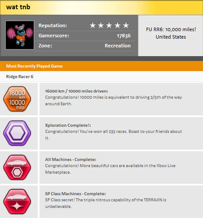
My Gamerpic is a happy little bugger with pom-poms in his celebratory dance of RR6 pwnage, and an FU to you. ;)
Just before the big event:
After:
My Gamerpic is a happy little bugger with pom-poms in his celebratory dance of RR6 pwnage, and an FU to you. ;)
Subscribe to:
Posts (Atom)